CBAC Avalanche Discussion
Thu, Dec 15, 2016 at 5:04 AM
Issued by: CBAC : Full Report
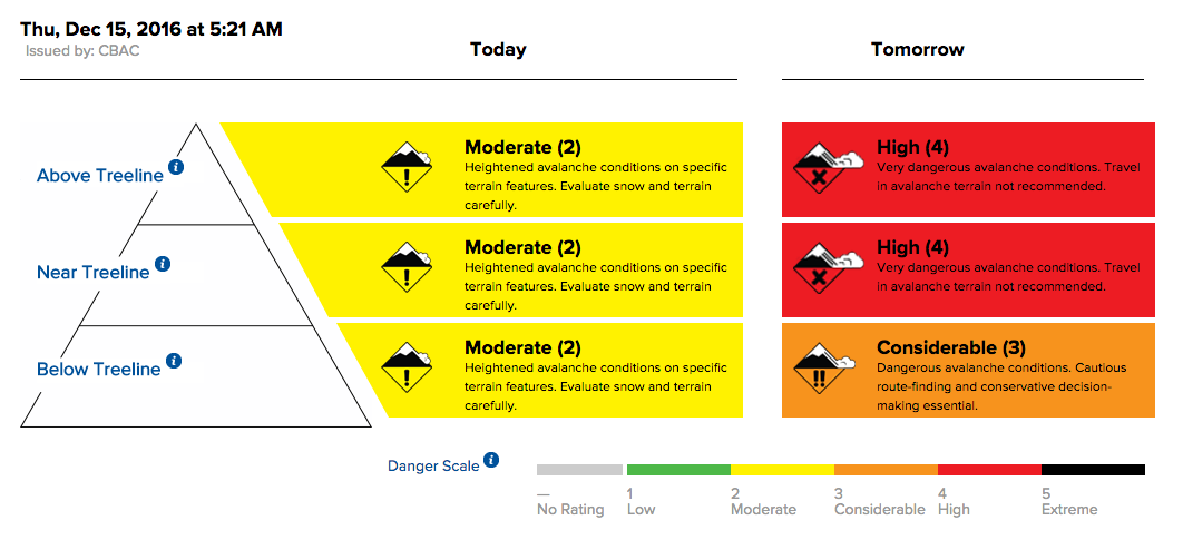
We have seen incremental snowfall, every few days since November 17th. This steady accumulation has been great to “build our base,” but also has developed a deepening slab above weak, sugary facets both in the mid-pack, and at the ground. We have many examples of snowpack tests from across our forecast area at all aspects and elevations showing this weak structure and potential for human and machine triggering. Whenever we see more snowfall or increased wind transport, these weak layers strain to adjust, and human triggering in the backcountry ticks higher.
Models suggest this to likely be the largest, most potent winter storm yet this season. Trying to not get excited, but hard to downplay the data. Our snowpack structure from around the zone suggests that 1-2” of snow water equivalent, SWE, should push us into HIGH avalanche danger tomorrow (1-2” SWE = 1-2 feet snow). We have the potential to see paths running far and wide as the overloaded weak layers flush.
If somehow we get skunked and only see yet another incremental load up to 12-15”, we will bring the snowpack to the brink, ease off, and leave it vulnerable to any further trigger (human) before going big. Areas closer or east of town, with a shallower, weaker snowpack should see a widespread avalanche cycle with even a foot of snow.
Stay tuned, we will do our very best to keep all informed the next 24-36 hours to the interesting evolution of this storm. Stormy seas ahead folks!
Reported By: Ian Havlick